

(Image source from: Twitter.com/ANI)
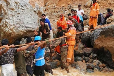
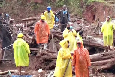
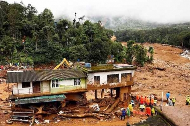
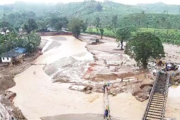
High-resolution images captured by Indian satellites show widespread damage and destruction caused by a landslide in Wayanad, Kerala. More than 280 people have been killed and more than 200 injured, although rescue efforts are still ongoing. Before and after images show that around 86,000 square meters of landslides and debris flowed along the Iruvaiphuzha River over a length of about 8 kilometers. Interestingly, the Indian Space Research Organization report also shows evidence of an ancient landslide at the same location, documenting its vulnerability. The National Center for Remote Sensing in Hyderabad, part of the Indian Space Research Organization, has deployed the high-resolution optical satellite Cartosat 3 and the RISAT satellite, which can see through cloud cover. The space agency said the landslide started at an altitude of 1,550 meters above sea level. The latest report accessed by NDTV suggests that there are traces of an ancient landslide at the same location. In the 'Landslide Atlas of India' 2023 prepared by ISRO, the Wayanad region was listed as prone to landslides.
#WayanadLandslide : ISRO releases satellite before and after images of landslide at Chooralmala in Wayanad district of Kerala#WayanadDisaster #WayanadLandslides #Kerala #Landslide #landslides #Wayanad #Meppadi #Vyithiri #Mundakai #Chooralmala pic.twitter.com/KGrzbUfH0H
— Soundar C / சௌந்தர் செ (@soundarc2001) August 2, 2024
ISRO satellite images show extensive destruction in Wayanad landslide. About 86,000 square meters of land slipped, causing a landslide almost five times the size of Rashtrapati Bhavan. The debris flow flowed nearly eight kilometers downstream, destroying towns and villages. According to ISRO, there are traces of an ancient landslide at the same location. The National Remote Sensing Center observed through the cloud cover with the Cartosat-3 and RISAT satellites. “Heavy rains caused large debris flows in and around the town of Chooralmala, Wayanad district, Kerala state, India,” the NRSC report said. A very high-resolution RISAT-SAR image from July 31, 2024 shows the full extent of the debris flow from the ridge to the edge of the liquefaction zone. The length of the stream is approximately 8 km. The crown zone is the reactivation of an old landslide. The main landslide rock has an area of 86,000 square meters. The debris flow widened the channel of the Iruvaniphuzha River and caused the embankment to burst. Homes and other infrastructure along the coast were damaged by the debris flow, and a 3D view from above the landslide showed that most of the hill was affected.
ISRO satellite images show widespread devastation at Wayanad landslide.
— VIVEK SHARMA (@vivek2223) August 2, 2024
The before and after images show that about 86,000 sqm of land slipped and the debris flowed for about 8 km along the Iruvaiphuzha river. pic.twitter.com/odh3hPCEUX
The area of the landslide is 86,000 square meters. Crown lies at an altitude of approximately 1550 meters above sea level. ISRO has prepared the 'Landslide Atlas of India', which has carefully mapped 80,000 landslides that have occurred in the last 20 years and lists landslides from Puthumala in Wayanad district and most of the landslide-prone state of Kerala. In the 2023 report of ISRO Chairman Dr. Somanath revealed about the landslide scenario.
(Video Source: The Indian Express)